TL;DR / Short answer
Construction progress drone documentation is scheduled aerial documentation of a jobsite from practical, repeatable viewpoints. It is worth paying for when the site has visible exterior progress, remote reviewers, important milestones, or enough moving parts that ground photos alone do not show the full picture. The package should be defined before the flight: recurring progress photos, construction milestone drone photos, a stakeholder-ready update, or an orthomosaic-style planning reference. It supports review and communication, but it does not replace surveying, engineering, roofing, insurance, code inspection, or hands-on trade review.
What construction progress drone documentation actually is
Random aerial photos are one-off images. They may look good, but they are not automatically useful when someone asks what the site looked like before paving, roof dry-in, exterior envelope work, or final grading.
Marketing photos are different. Their job is to show the project well. Jobsite drone documentation is planned around comparison, review, and delivery.
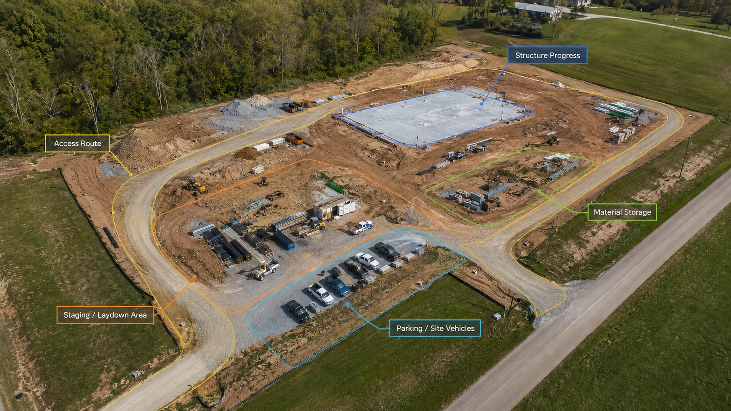
A Milestone Capture visit is tied to one project transition: foundation, framing, roofing, exterior work, paving, or turnover. Recurring Progress Documentation fits weekly, biweekly, monthly, or phase-based records. Stakeholder Update Deliverables are curated packages for owners, clients, investors, or remote teams that do not need every raw file. TwoBit lists date-based image sets, repeatable viewpoint captures, milestone packages, curated stakeholder-ready updates, progress zones, photo indexes, and review-friendly file organization as construction progress deliverables.
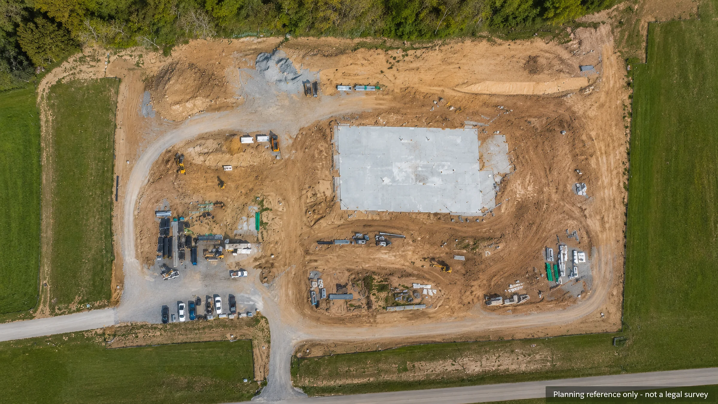
Orthomosaic Mapping can be added when the project needs a map-style overhead reference for planning, site orientation, documentation, or comparison. That is separate from standard progress photo sets and should be labeled as a planning reference, not a legal survey. TwoBit's orthomosaic service is positioned for site-wide overhead imagery, planning support, property documentation, progress comparison, organized exports, and planning-support-only use rather than legal survey use.
Define the deliverable before the flight. Otherwise, you can end up with good-looking photos that do not answer the project question.
When drone progress photos are worth it
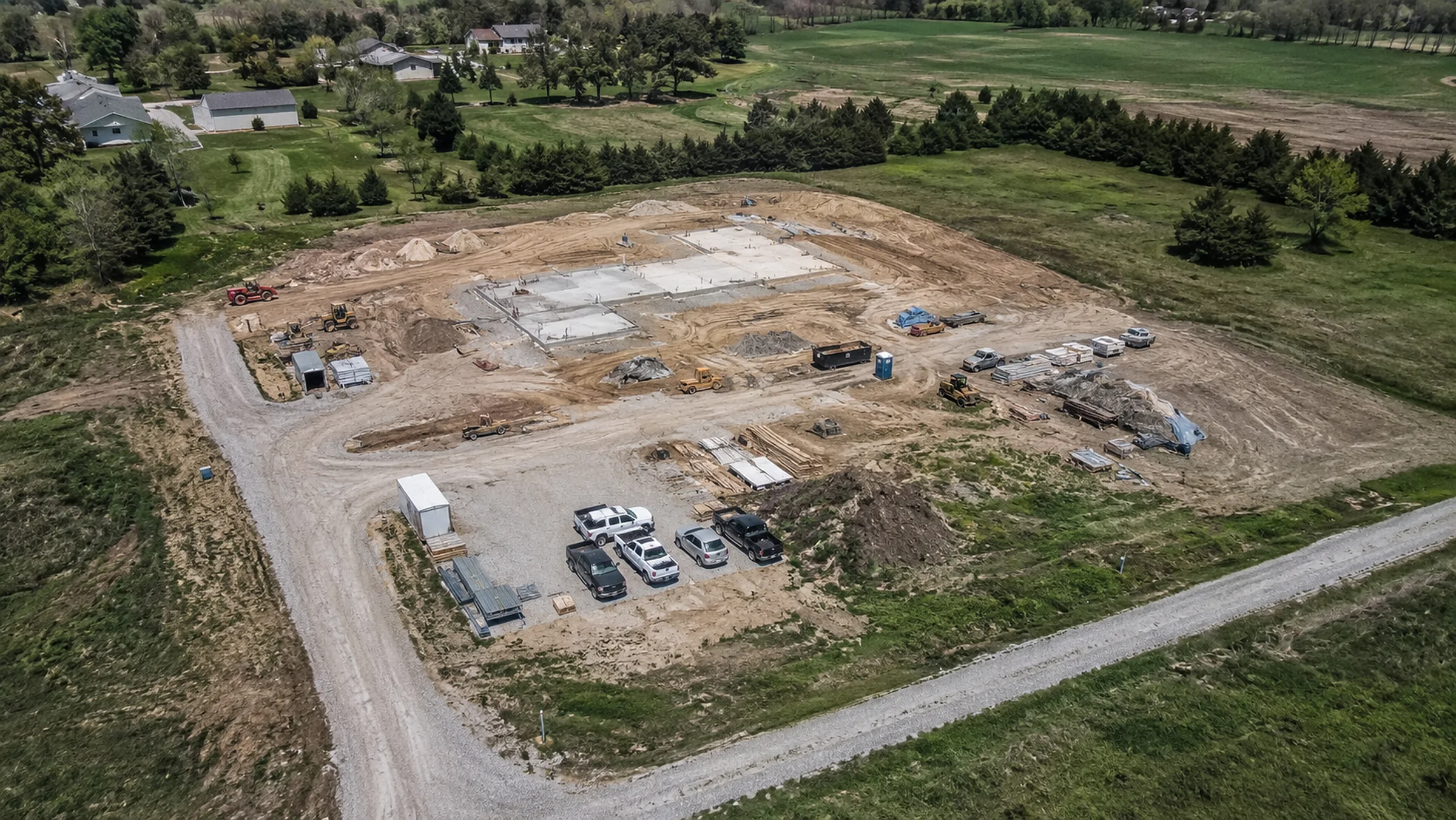
Drone construction progress photos are worth it when the aerial view answers a real project question.
They usually fit when the owner or investor is not always on site, exterior phases are visible, remote reviewers need updates, or the jobsite is large enough that ground photos miss the relationship between access, staging, laydown areas, structures, parking, drainage, and surrounding property.
Recurring site records matter when the project will be reviewed over time. A single milestone visit may be enough before a grading change, before roof cover, after a major delivery, or before turnover.
I would not recommend recurring aerial progress photography for every construction site. If the work is mostly interior, the exterior changes slowly, or one milestone record answers the question, a smaller Site Documentation or milestone package is usually the cleaner buy. If nothing visible changed, do not buy another identical folder.
What should be captured every visit
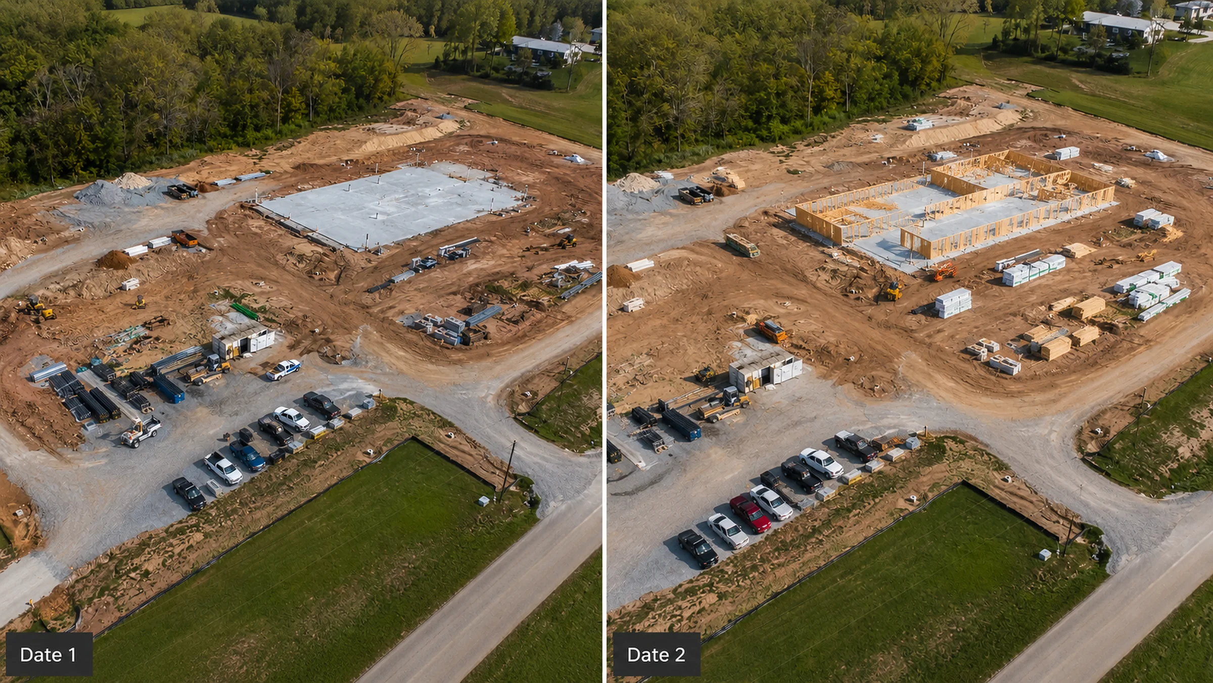
A good capture list should be simple enough to repeat and specific enough to matter. For most commercial projects, that means:
- same wide overview angles where practical;
- site entrance and access routes;
- staging, laydown, and material areas;
- grading or earthwork areas;
- structure progress;
- roof or exterior envelope progress when relevant;
- parking, drives, drainage, or visible utility areas;
- owner-requested or contractor-requested viewpoints;
- close-detail views only when safe and useful;
The most useful record is not always the prettiest image. A plain view from the same corner may be more valuable than a dramatic angle that cannot be compared with the next visit.
How often should a construction site be photographed?
There is no universal cadence. The schedule should follow project speed, reviewer needs, budget, and visible change.
Weekly capture often fits fast-moving visible construction. A steel package going up every few days may justify weekly visits. Once the work moves mostly inside, that same project may shift to milestone-only updates. Biweekly can work for steady commercial jobs. Monthly is usually enough when exterior progress is slower. One-time before/after capture can be enough for smaller exterior projects.
If the site looks the same from the air two visits in a row, the cadence is probably too tight.
Weather matters. If wind, rain, poor visibility, or bad light would make the flight unsafe or the images weak, rescheduling is better than forcing a poor record. TwoBit's FAQ states that flight work is scheduled around safe and useful capture conditions and can be rescheduled when weather would compromise the deliverables. Near controlled airspace, FAA authorization may affect timing; the FAA says LAANC provides drone pilots access to controlled airspace at or below 400 feet.
Drone photos vs. phone photos from the jobsite
Phone photos are valuable. Ground crews can document close details, trade work, damage, deliveries, and field questions quickly.
The issue is whether those photos show the whole site and stay organized. Phone images often get spread across texts, email threads, camera rolls, and project apps. Aerial records help establish date-based context from the same general views.
Procore's photo documentation guidance emphasizes capturing photos from jobsite devices, marking up images for clarity, organizing project photos, and keeping a complete archive of project imagery so teams can find and use the files later. The best record usually uses both: ground photos for close details, aerial progress photography for construction-site orientation and comparison.
What a useful progress package should include
A superintendent, owner, lender, and investor may not need the same folder.
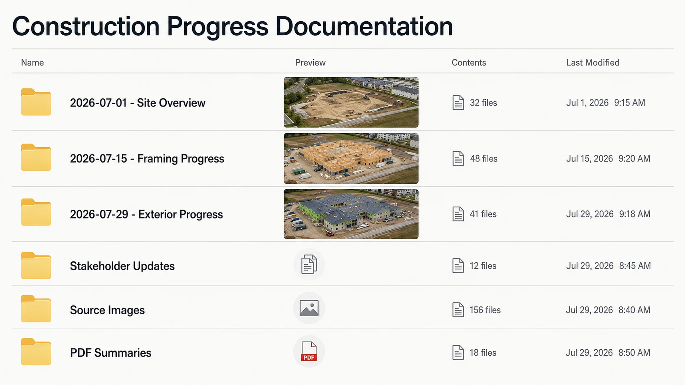
A practical package may include date-based folders, repeatable viewpoints, overview images, milestone views, curated selections, labeled zones, delivery notes, and an optional PDF summary. For example, a project owner may not need 200 raw files. They may need 12 clean views labeled by date and area, plus a smaller source-image folder for deeper review.
For stakeholder construction updates, curation beats a file dump.
What drone documentation can and cannot prove
Aerial records are strongest when they give people a shared view of the site: what changed, where materials are staged, what access looks like, and which areas may need closer ground review. They can support visual records, planning conversations, vendor coordination, progress comparison, remote review, and owner updates.
They cannot replace a licensed survey, engineering certification, roofing determination, insurance adjustment, code inspection, moisture diagnosis, defect diagnosis, or guaranteed detection of every issue. TwoBit's FAQ keeps maps, overlays, and measurements framed as reference outputs unless a licensed survey scope is separately handled, and it says aerial imagery does not replace qualified hands-on inspection, engineering, roofing, or insurance determinations.
For paid commercial flight work under the FAA's Small UAS Rule, Part 107, the FAA says the remote pilot must obtain a Remote Pilot Certificate. Survey limits are separate. Missouri law defines professional land surveying to include work involving land boundaries, topographic surveys, elevations, maps, drawings, improvements, and certain real-property-rights issues. Missouri also prohibits practicing professional land surveying without the required license or certificate of authority.
So drone site documentation in Missouri can support planning and records, but a map-style deliverable should not be treated as a legal survey unless the proper licensed survey scope is involved.
What affects pricing
TwoBit's Pricing page uses starting points, not flat rates for every site. For construction progress work, the current anchors are Recurring Progress Documentation from $350 per visit, Milestone Capture from $375, and Stakeholder Update Deliverables from $475.
Final pricing depends on site size, visit frequency, repeatable views, travel, access or airspace complexity, summary packaging, and any mapping, thermal, or extra reporting. TwoBit's pricing page notes that recurring frequency, site size, summary deliverables, curation, broader distribution-ready deliverables, and travel can affect the final quote.
What to send before requesting a quote
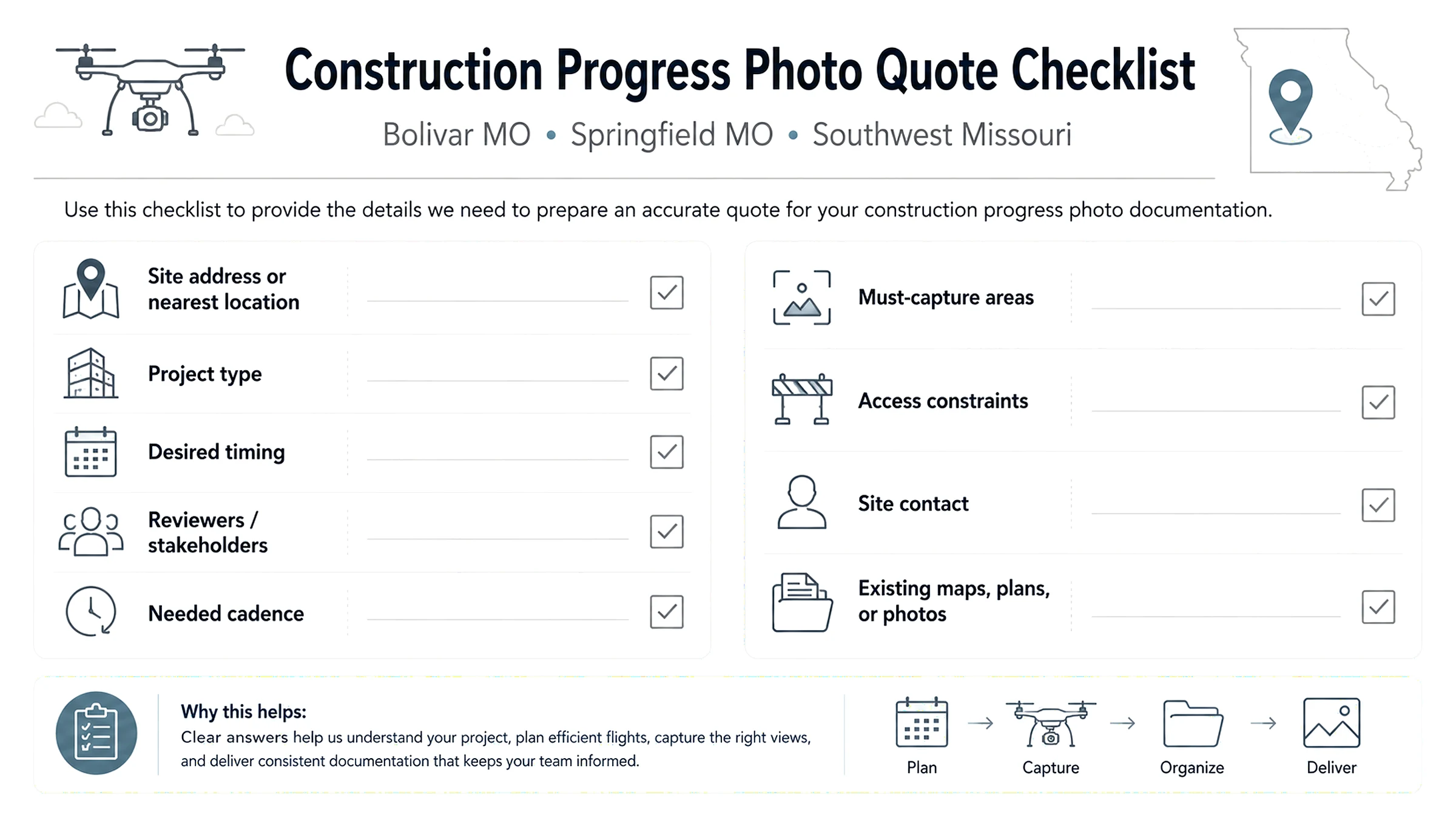
Send the site address or nearest location, project type, desired timing, who will review the deliverables, needed cadence, must-capture areas, access constraints, site contact, and any existing maps, site plans, or photos.
TwoBit's FAQ asks for the site address or nearest location, service need, timing, intended reviewer, access constraints, and helpful existing photos, plans, maps, or project descriptions.
Missouri service fit
TwoBit Aerial is commercial-first and based in Bolivar, Missouri. Its Service Area page says priority starts with Bolivar-area work, then Springfield, then Southwest Missouri, with the rest of Missouri available by quote when the work supports the travel.
For construction progress photos in Bolivar MO, the local fit is straightforward: shorter travel, easier recurring visits, and simpler scheduling. Construction progress photos in Springfield MO can also make sense when the scope supports the regional trip. Larger or recurring Southwest Missouri drone services, and statewide Missouri projects, can be quoted when the deliverable value supports the travel.
Bottom line
Construction progress documentation is worth paying for when the project needs repeatable perspective, organized records, and clear updates for people who cannot always be standing on site. It is about creating a visual record the project team can use.
For a recurring job, start with Construction Progress Documentation. For one phase record, Milestone Capture may be enough. To scope the real site, send the project address, phase, desired cadence, must-capture areas, site contact, and intended reviewer through Contact / Email Project Details.
FAQ
1. How often should construction progress drone photos be taken?
Weekly often fits fast exterior progress, biweekly fits steady commercial work, monthly fits slower visible change, and milestone-based visits fit defined phases.
2. What should be included in a drone progress documentation package?
Date-based folders, repeatable viewpoints, overview images, milestone views when needed, delivery notes, and a curated update set for owners, investors, lenders, or remote reviewers.
3. Are drone construction photos better than phone photos?
Not across the board. Phone photos are better for close field details. Aerial records are better for whole-site context, repeatable views, and organized comparison.
4. Can drone progress photos be used for owner or investor updates?
Yes. Curated progress packages can support owner updates, investor snapshots, and team communication. TwoBit describes stakeholder update deliverables as curated visual packages built for owner updates, investor snapshots, and team communication.
5. Can drone progress documentation include mapping?
Yes, if scoped. Orthomosaic mapping can provide a map-style overhead reference for planning, documentation, and progress comparison, but it should be labeled as a planning reference unless a licensed survey workflow is involved.
6. How much does construction progress drone documentation cost in Missouri?
TwoBit's current starting points are recurring progress documentation from $350 per visit, milestone capture from $375, and stakeholder update deliverables from $475. Final pricing depends on the actual scope.
7. Do you need an FAA-certificated remote pilot for commercial construction progress photos?
Yes. For paid commercial work under FAA Part 107, the FAA requires a Remote Pilot Certificate. Controlled airspace can also require FAA authorization before flight; FAA LAANC provides access to controlled airspace at or below 400 feet.
8. Can drone maps replace a legal survey?
No. Drone maps can support planning, site documentation, and visual review, but Missouri defines professional land surveying separately and prohibits practicing as a professional land surveyor without the required license or certificate of authority. Use map-style deliverables as planning references unless a licensed survey workflow is actually involved.
Sources and reference basis
These links support the article's operating, source, and internal-link basis. Internal article links use descriptive anchor text consistent with Google Search Central link guidance.
- FAA Remote Pilot Certificate
- FAA LAANC
- Missouri professional land surveying definition
- Missouri unauthorized professional land surveying practice prohibition
- Procore photo documentation
- Google Search Central link best practices
- TwoBit Construction Progress Documentation
- TwoBit Pricing
- TwoBit Service Area
- TwoBit FAQ
- TwoBit Orthomosaic Mapping