Short answer
A useful aerial documentation package for a commercial drone inspection is organized visual evidence, not simply every image captured during a flight. Depending on the scope, it may include asset overviews, high-resolution RGB detail references, annotations, paired thermal views, an image index, delivery notes, and a concise summary. Define the deliverable before the flight, and keep diagnosis or regulated determinations with the qualified professional responsible for them.
Start with the decision, not the drone
The first scoping question should be: what decision or conversation must this documentation support? A property manager may need a shareable exterior record. A roofing contractor may need roof overviews and requested detail references. An asset team may need consistent views of a water tower, utility pole, treatment-facility component, or communications structure. Those are different jobs even if the same aircraft could capture them.
TwoBit uses the public terms drone inspection support and aerial documentation because the output is visual evidence for review. The FAA's commercial-operator guidance explains the Remote Pilot Certificate requirement for the remote pilot in command conducting qualifying Part 107 work. That flight credential does not make the pilot a roofer, engineer, surveyor, code inspector, or insurance adjuster. The reviewer and the deliverable must be chosen with that boundary in mind.
Not every project needs a formal written report. A smaller scope may be best served by organized overview and detail images. A more involved commercial review may justify annotations, an index, sensor pairs, or a summary. Buying the largest package by default adds files, not necessarily value.
ASTM is also developing work item WK86230 for drone assessments of commercial real estate. Its stated scope centers on shared terminology and guidance for capture, evaluation, and delivery. Because it remains a work item, it should be treated as evidence that package consistency matters, not as a published certification standard.
What a useful inspection package should include
The exact contents should change with the asset and reviewer, but a strong package usually has six parts. This framework is a buyer checklist, not a claim that every item belongs in every quote.
Scope record
01The asset, capture date, review goal, requested areas, and known exclusions.
Orientation views
02Wide images that show where the asset or detail sits within the property or system.
Detail references
03Closer visual references captured from lawful, practical, and safe aerial positions.
File organization
04Folders, names, dates, and an index that let another reviewer find the right view later.
Optional review aids
05Annotations, RGB and thermal pairs, comparison views, or a concise summary when scoped.
Limits and handoff
06Plain boundaries around what the imagery shows and who should make the next determination.
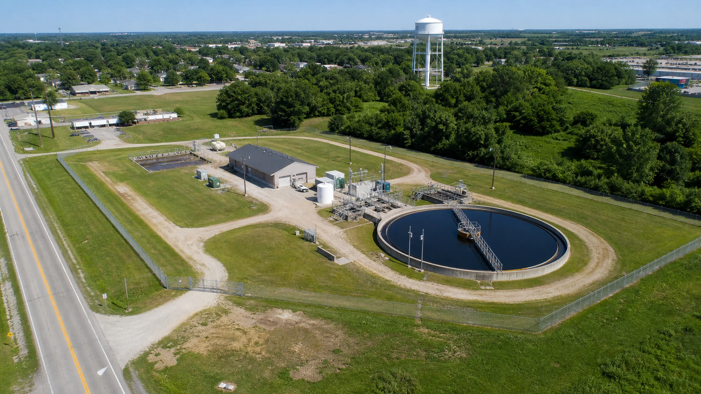
The orientation views are what keep the detail images usable. A close image of a drain, insulator, parapet, panel, or connection is more valuable when the reviewer can tell where it belongs. File organization preserves that context after the flight crew leaves.
Three practical delivery levels
Commercial drone inspection deliverables can be scoped in levels without turning them into rigid packages. The useful level is the one that matches the reviewer and the next action.
Organized visual record
Best for
A clear condition record or focused vendor conversation.
Can include
Overview images, selected detail references, date-based folders, and delivery notes.
Review-ready package
Best for
Teams that need faster orientation and a smaller set to share.
Can include
A curated image set, labeled zones or callouts, an index, and optional summary notes.
Specialized documentation
Best for
Thermal screening, recurring comparison, or map-style site context.
Can include
Paired sensor views, repeatable references, or scoped mapping outputs with explicit limits.
A curated review set should not be confused with the complete source-image folder. When both are included, label them separately so the reviewer can start with the concise set and still reach supporting imagery when needed.
How deliverables change by asset type
An inspection package should reflect the physical asset, the safe capture positions available, and the expertise of the person who will review the files. The same template should not be forced onto every roof, property, construction site, or utility asset.
Roof overviews, perimeter context, penetrations, drainage areas, equipment, and requested detail references.
Aerial roof documentation is not a roof diagnosis or repair specification.
Building elevations, access points, exterior areas, perimeter context, and selected follow-up views.
Property imagery is not an appraisal, code inspection, structural conclusion, or boundary survey.
Asset overviews and detail references shaped around water, utility, treatment-facility, or communications assets.
The package supports qualified review; it does not make engineering, utility, or compliance determinations.
Date-based records, repeatable overview angles, milestone views, and stakeholder-ready selections.
Progress imagery documents visible change; it does not certify completion, quality, or contract compliance.
The U.S. Department of Energy has documented drone-supported inspection work involving water storage tanks, piping corridors, fire-water tanks, roof systems, and power distribution at the Savannah River Site. That is a useful industry example of asset-specific capture; it is not presented here as TwoBit project history or proof of identical capability on every site.
What a thermal package needs to explain
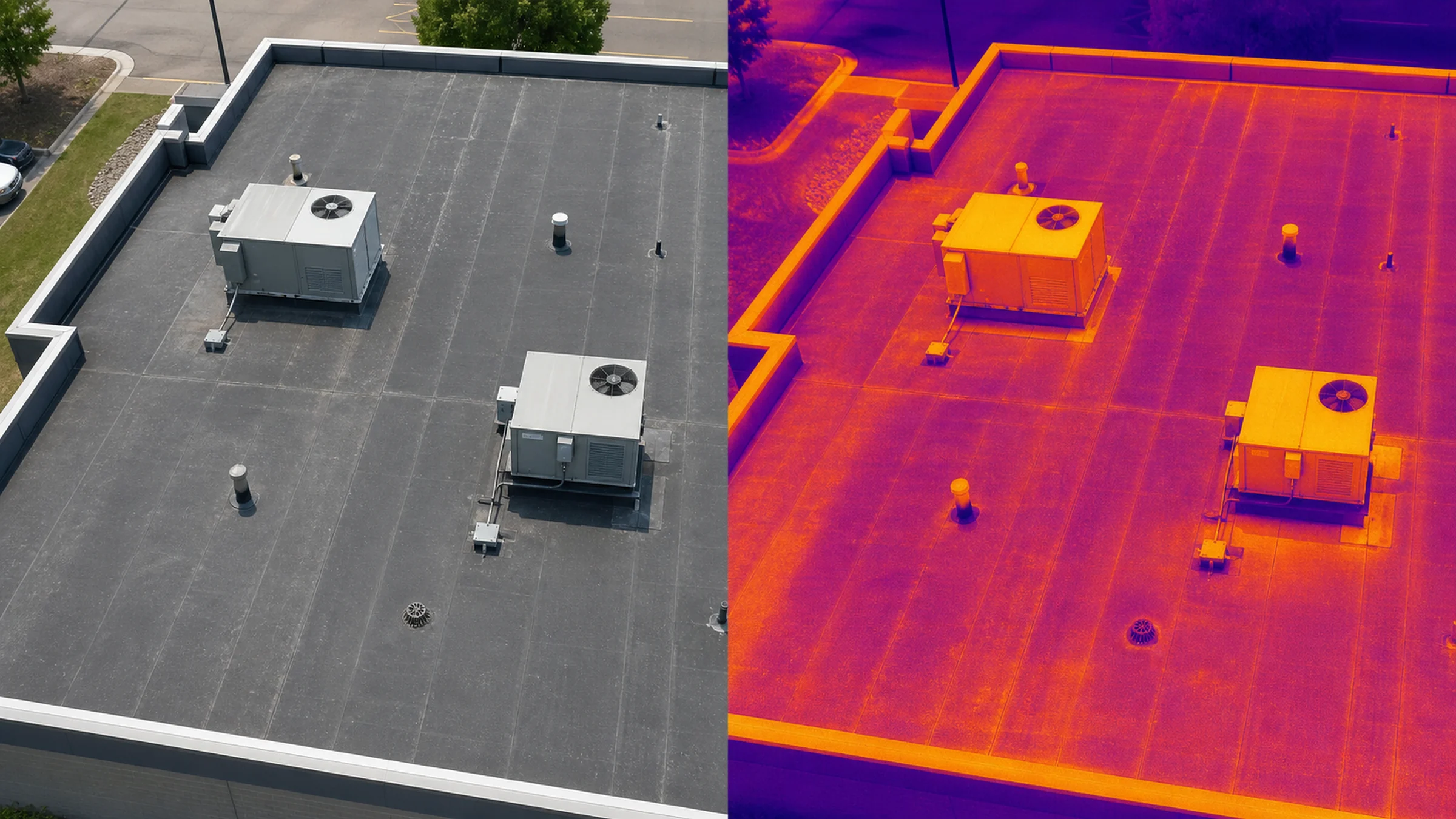
Thermal files need more context than a dramatic color palette. A useful thermal screening package should identify the asset or area, pair recognizable RGB views with thermal views, record relevant conditions, and explain which apparent temperature patterns are being flagged for qualified follow-up.
ASTM C1153-23 addresses equipment, meteorological conditions, roof construction, operator practices, and verification for infrared roof-insulation imaging. The current listing also states that the method does not determine the cause of moisture or its point of entry. In buyer terms, thermal contrast is not proof of moisture or a leak. It is screening evidence that may help focus the next review.
Pair the views
Show the thermal pattern beside an RGB image that preserves physical context.
Record conditions
Note timing and environmental or material conditions that can affect interpretation.
Use neutral labels
Identify an apparent anomaly or follow-up area without naming an unsupported cause.
Name the next reviewer
Route the evidence to the roofing, facilities, electrical, engineering, or other qualified professional responsible for the determination.
For a deeper roof-specific explanation, read Thermal Drone Roof Screening: What It Can and Cannot Show or review the scoped roof thermal screening service.
What aerial documentation can and cannot establish
Aerial documentation can
- record visible surfaces and conditions at the capture time
- connect detail references to a wider site or asset view
- support remote review and vendor communication
- create before-and-after or recurring visual comparisons
- help qualified reviewers focus follow-up work
It does not establish
- hidden or below-surface conditions that the sensor cannot observe
- cause, code compliance, structural adequacy, insurance coverage, or repair scope
- identification of every concern
- a legal boundary or survey result
- a professional conclusion outside the provider's documented scope
Aerial documentation does not establish cause, code compliance, structural adequacy, insurance coverage, or repair scope. An orthomosaic or map-style planning reference is not a legal survey.
These limits do not make the imagery weak. They make the handoff honest. A qualified reviewer can work more efficiently when the visual record is organized, the capture conditions are visible, and the package does not overstate what a camera can establish.
If the decision requires touch, testing, material removal, interior access, engineering analysis, survey authority, code interpretation, insurance determination, or a repair specification, plan that professional review separately. For roof-method selection, see the comparison of drone roof documentation and traditional inspection methods.
A buyer's quality-control checklist
Use this checklist before accepting a quote and again before closing the delivery. A polished package should be understandable to someone who was not standing beside the pilot.
- 01The review question is written plainly before capture begins.
- 02Wide views make each detail image easy to locate.
- 03Folders and file names follow the asset, zone, elevation, or capture date.
- 04Annotations identify a location or observation without presenting an unsupported diagnosis.
- 05Thermal images are paired with recognizable RGB context when thermal is in scope.
- 06Capture conditions, exclusions, and access limits are recorded when they affect review.
- 07Curated selections are clearly separated from larger source-image folders when both are delivered.
- 08The package says what kind of qualified follow-up may still be needed.
The shortest useful package may outperform a larger file dump when its images are selected, labeled, and organized around the actual review question.
What to send before requesting a quote
Better inputs produce a cleaner scope. Send enough context for the provider to plan the capture and delivery without guessing.
- site address or the nearest practical location
- asset type and approximate project size
- the question the imagery needs to help answer
- who will review the files
- must-capture areas and known concerns
- preferred timing or a recurring schedule
- site access details and an on-site contact
- known airspace, security, or operating constraints
- existing plans, photos, maps, or previous documentation
- preferred output: organized images, annotations, summary, thermal pairs, or map-style context
If your team already knows it needs annotations, paired thermal and visual images, an orthomosaic planning reference, recurring comparisons, or a concise summary, say so before scheduling. Those outputs change capture planning as well as post-flight work.
Commercial inspection support in Southwest Missouri
TwoBit Aerial is based in Bolivar and provides commercial-first inspection support across Bolivar, Springfield, and Southwest Missouri, with larger regional Missouri projects considered by scope. Roof, property, infrastructure, thermal, and recurring documentation needs are quoted around the actual asset, reviewer, access conditions, travel, and delivery requirements.
Review the current service area, pricing guidance, and published project examples, then send the project location and intended output through the contact page. Specialized infrastructure work is confirmed case by case rather than promised from a generic checklist.
Bottom line
A commercial drone inspection is only as useful as its handoff. Define the review question, capture wide context and necessary details, organize the files around the asset, add annotations or specialized outputs only when they help, and state the limits plainly.
Start with TwoBit's commercial drone inspection services to choose the right inspection path. Then use the project address, intended reviewer, must-capture areas, timing, and preferred delivery format to request a scope.
Frequently asked questions
These answers focus on inspection deliverables. The broader commercial drone services FAQ covers scheduling, service fit, operating conditions, and project preparation.
1. What does a commercial drone inspection include?
The scope can include site or asset overview images, organized high-resolution RGB photos, detail references, optional annotations, paired thermal views, file indexes, delivery notes, or a concise summary. The exact package should be agreed before the flight.
2. Is a written drone inspection report always included?
No. Not every project needs a formal written report. Some buyers need an organized visual record, while others need a curated package with annotations or summary notes. Confirm the output and reviewer before pricing the flight.
3. Will I receive every photo captured during the flight?
That depends on the agreed scope. A package may include a curated review set, a larger source-image folder, or both. The quote should distinguish between selected deliverables and broader source files.
4. Are annotations the same as a professional diagnosis?
No. An annotation can identify a location, visible feature, or requested follow-up area. It does not establish cause, code compliance, structural adequacy, insurance coverage, or repair scope.
5. Can a drone inspection replace a hands-on inspection?
No single capture method answers every question. Aerial imagery can document visible and difficult-access areas, but touch, testing, material removal, interior review, or specialist judgment may still be required.
6. What should a thermal drone inspection package include?
A useful thermal package should pair thermal and RGB views, identify the asset or location, record relevant capture conditions, and state that thermal contrast is screening evidence rather than proof of moisture, a leak, or cause.
7. Can a drone inspection package include an orthomosaic map?
Yes, when the site benefits from a map-style overhead reference. An orthomosaic can support orientation, planning, and visual records. An orthomosaic planning reference is not a legal survey; boundary or survey determinations require the appropriate licensed scope.
8. How much does commercial drone inspection documentation cost?
Pricing depends on the asset, site size, capture depth, travel, access, sensor needs, annotations, summary packaging, and recurring requirements. TwoBit publishes starting points for straightforward services and quotes specialized infrastructure work by scope.
9. What should I send before requesting a drone inspection quote?
Send the location, asset type, project goal, intended reviewer, must-capture areas, timing, access details, site contact, and any useful plans, maps, or previous photos. Also describe the delivery format your team expects.
Sources and reference basis
Where the guidance comes from
This guide combines TwoBit Aerial's public service scope with primary operating, infrared-screening, and government infrastructure references. It is buyer guidance for scoping documentation, not a roofing, engineering, survey, code, utility, or insurance determination.
- FAA guidance for certificated remote pilots and commercial operators
Primary source for the Part 107 operating framework and Remote Pilot Certificate requirement for qualifying small-drone work or business operations.
- ASTM C1153-23: infrared roof-insulation imaging practice
Active ASTM reference for infrared roof-insulation imaging conditions, verification, and the limitation that infrared imaging does not determine moisture cause or entry point.
- ASTM WK86230: guide for drone assessments of commercial real estate
ASTM work item currently under development for shared terminology and guidance around capture, evaluation, and delivery of drone imagery supporting commercial real-estate assessments. It is not a published certification standard.
- U.S. Department of Energy infrastructure inspection example
Government example of aerial imagery supporting review of water storage, piping, roof, power-distribution, and other difficult-access infrastructure assets.
- TwoBit Aerial drone inspection services
Defines TwoBit's actual public scope: usable visual records, overview imagery, detail references, optional annotations, and organized delivery.
- TwoBit Aerial thermal imaging services
Defines thermal work as condition-dependent screening support paired with visual context rather than definitive diagnosis.
- TwoBit Aerial pricing guide
Current public starting points and the scope factors that can change a commercial inspection quote.